MDA’s Wayne Hoyle, Senior Director of Business Development, gave a detailed presentation at the GeoIgnite conference about the capabilities of their new CHORUS Synthetic Aperture Radar (SAR) satellite constellation.
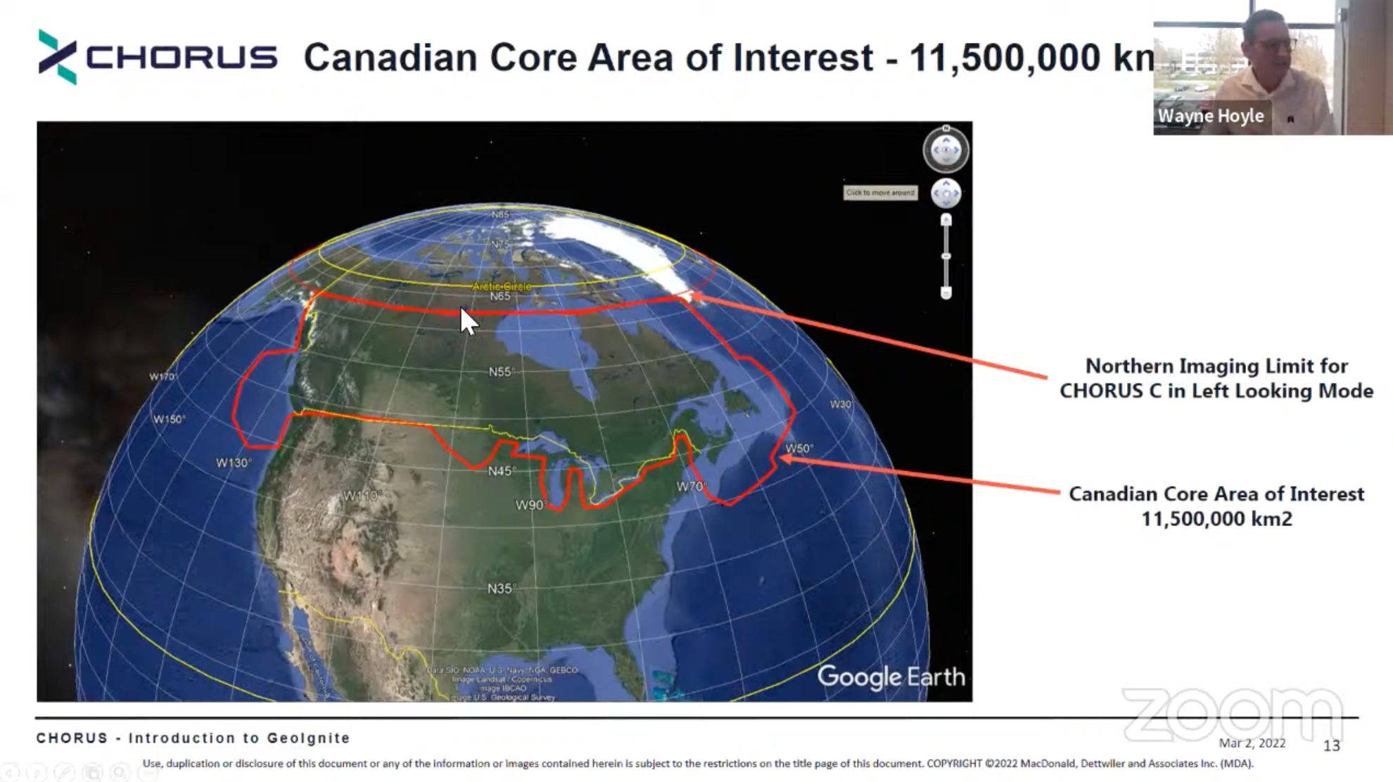
According to Hoyle, CHORUS’ pair of C- and X-band satellites will have dramatically increased imaging capabilities compared to RADARSAT, and will feature faster tasking and image downlinking. They will also have an inclined orbit that trades off a lack of polar imaging for more frequent and more comprehensive imaging in the “Canadian Core Area”.
While it may seem like a gamble to deviate from the sun-synchronous polar orbit used by so many SAR constellations, including MDA’s own RADARSAT, Hoyle made the case that it’s a smart bet.
C- and X-band together
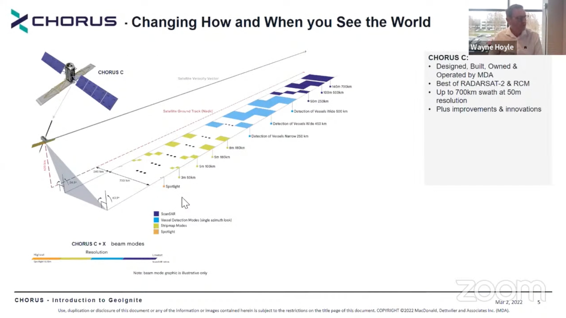
Hoyle began with a quick overview of CHORUS. The main CHORUS satellite will be MDA’s 4th Generation C-band SAR satellite, but it will be paired with a trailing X-band smallsat provided thanks to an agreement with ICEYE.
The combination will allow for both broad area coverage and high-resolution spotlight data. They will be in an inclined low-earth orbit (LEO), with its maximum latitude topping out at 62.5°. The inclined orbit means that CHORUS will be changing its time of imaging around 20 minutes earlier every day, with a ten-day data cycle.
The CHORUS C-band satellite is significantly larger than its predecessors. Its mass is 2,200kg. It has a solar array over five times larger than the RADARSAT constellation, a SAR antenna that’s nearly double the size at 18.5m2, right and left-looking imaging directions, and over 300Mbit/s in downlink bandwidth to regional ground stations and through “cloud-based capabilities.”
(The ICEYE X-band smallsat is comparatively tiny at 115kg, in line with other SAR smallsats.)
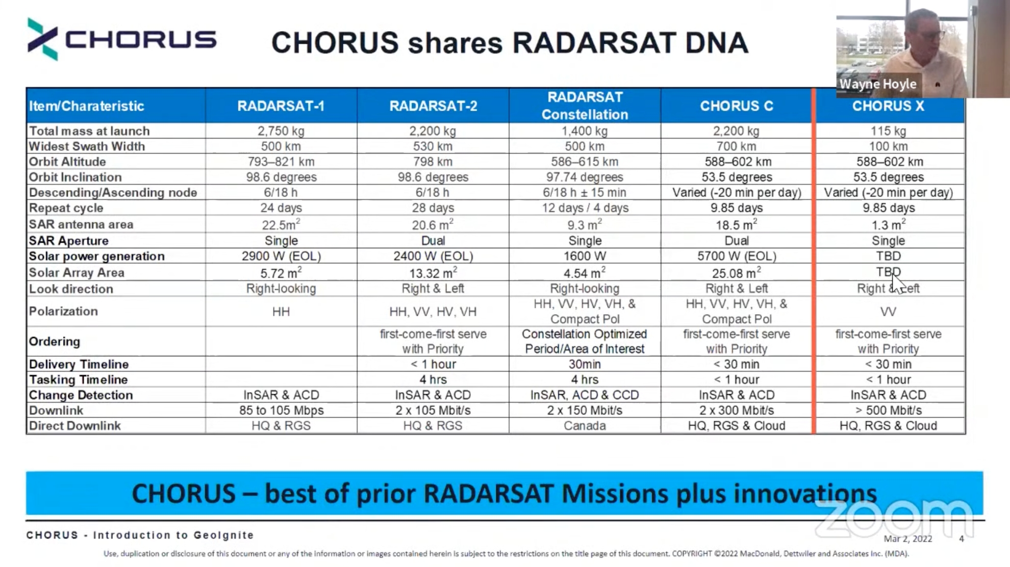
Hoyle said that a key aspect of these new satellites will be “fast tasking and near-real time downlink,” where they can be tasked dynamically and downlink to ground stations around the world. The C-band satellite will have 20 minutes of tasking, the X-band satellite will have 3 minutes of tasking, for a combined tasking time of 23 minutes. He said they will be putting in “a significant amount of effort in development of machine learning” to be able to cross-cue between the satellites.
For customers, this means that they’ll be able to provide “priority-based ordering”. Like with RADARSAT-2—but not with RADARSAT Constellation—customers will be able to specify “the exact location they’re looking for and when they want it to be collected,” on a first-come first-served basis. The tasking timeline will be less than an hour, and the delivery timeline less than 30 minutes.
The C-band satellite will image up to a 700km swath at 50m resolution, all the way down to 3m resolution imaging at 50km and an additional spotlight mode, along with a variety of vessel detection modes. The X-band satellite will contribute 100km swath scan mode, strip mapping, and a 1m spotlight—a resolution which can’t be achieved by the C-band satellite.
Real-world examples
Hoyle showed the wide area and resolution differences with CHORUS, starting at the “country-wide” 700km images from the C-band satellite, then zooming right down to the 0.5m spotlight imaging from the ICEYE X-band satellite. He also showed how the two satellites would work in concert: with the C-band satellite taking broader pictures of the area, then the X-band satellite following and getting higher-resolution images over the course of several passes.
He then showed CHORUS’ inclined orbit, and how there are much smaller “diamond” spaces where the satellites can’t take images. While the maximum latitude of 62.5° does rule out polar monitoring, the tradeoff is that “92.6% of the 1100 kilometers [of the Canadian Core Area] was covered in a unique way” by the satellite passes—far more than can be covered by the polar orbits of many current SAR constellations, including MDA’s own RADARSAT satellites.
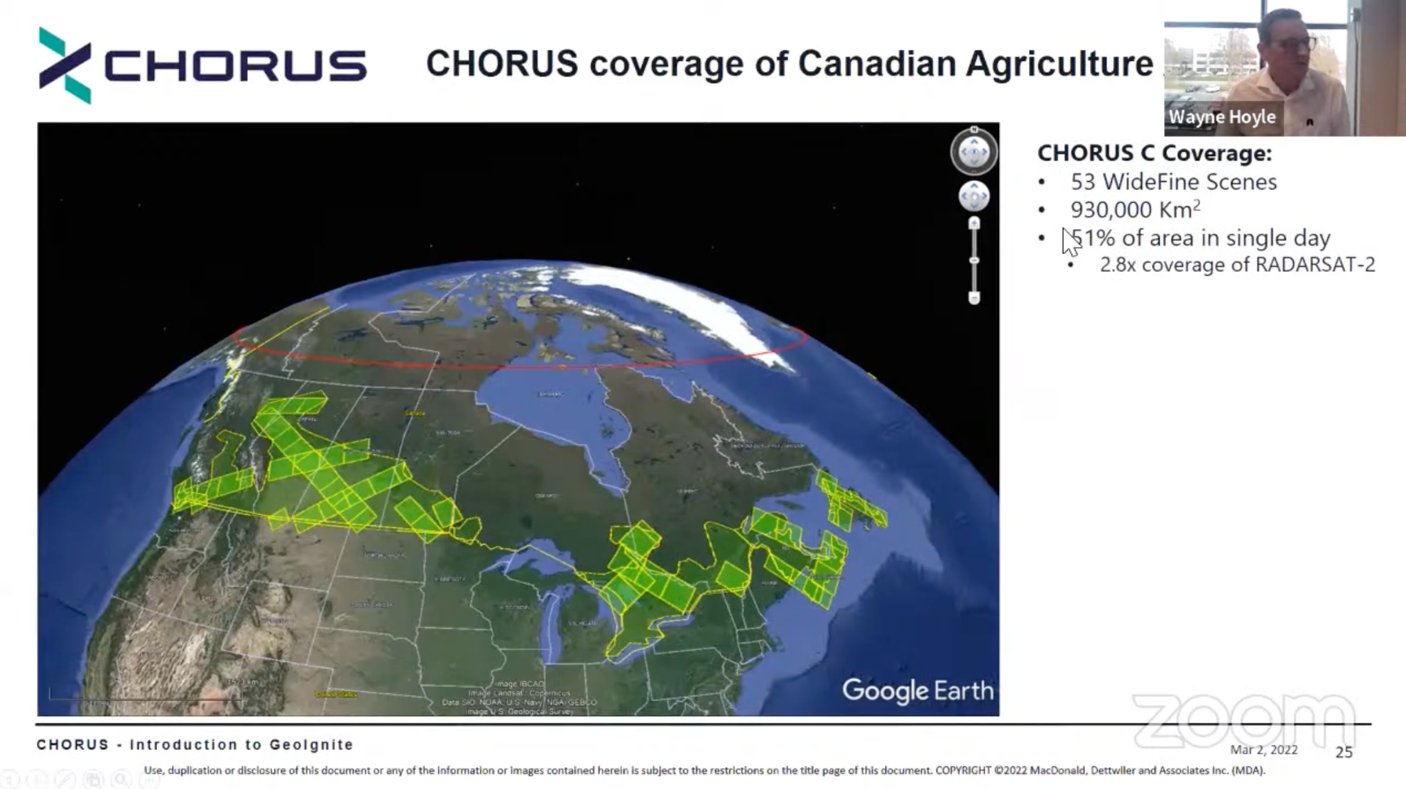
He used two real world examples: agricultural monitoring and iceberg monitoring. For agriculture, he said that CHORUS could cover 51% of the relevant areas in Canada in a single day, well above what RADARSAT is capable of. The area for iceberg detection will increase by 300km, with 63% coverage in a single day. The increased size and coverage could dramatically reduce the necessity for aircraft- and ship-based iceberg monitoring.
Hoyle concluded his prepared presentation by saying that it will provide significant improvements over the current RADARSAT, and will service a much greater variety of use cases than was possible before.
GeoIgnite Chair Jonathan Murphy posed an interesting question of “where did the CHORUS name come from,” and Hoyle explained how it will have a number of satellites “working together as one,” and that these two satellites are “only the first part.” The projected timeline came up, and Hoyle said that “we’ll have a better idea once we have achieved mission CDR (Critical Design Review),” but they can’t announce a launch date until that’s done.
Asked about further satellites, they said that “they will build up the constellation as it meets demands,” including possible polar satellites at some point in the future, though he believes that “the RCMs are doing a fantastic job” and that there’s “tremendous coverage” of the poles from existing SAR satellites. Finally, he said the mission life is 15 years, though the X-band satellites will need to be renewed more frequently, as is typical for SmallSats like the ICEYE satellites.