
A Canadian division of a U.S. company is playing a keystone role in a NASA-French led satellite mission.
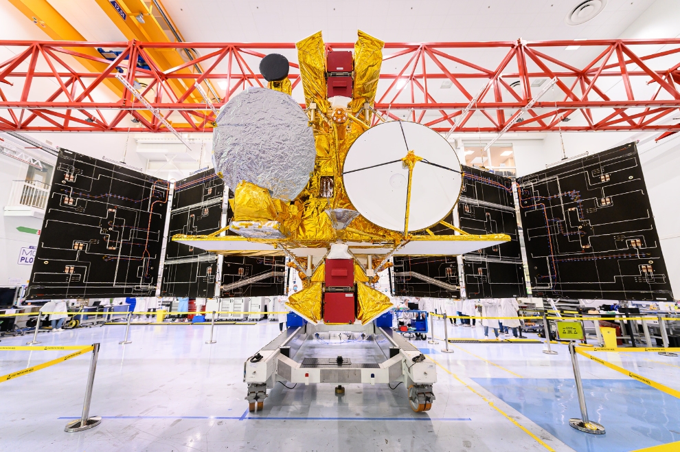
California-based Communications & Power Industries Inc. (CPI), which has an office in Georgetown, Ont., supplied a crucial part of the wide-swath radar instrument that will fly aboard the Surface Water and Ocean Topography (SWOT) satellite slated for launch early on Friday (Dec. 16).
CPI Canada is providing a set of devices known as extended interaction klystrons (EIKs) that will amplify the power on the radar instrument. The amplified signals will allow microwave pulses to flow from one antenna on SWOT to the Earth’s surface, to measure water surface elevation. Then two antennas on SWOT will pick up the signal to measure elevation precisely in two dimensions.
Applications for this information are vast, but on the largest scale it will help Canadian scientists learn how lakes, coastlines and rivers are responding to climate change and will assist with community management of water. SWOT can look at 90% of the Earth’s surface, including a great deal of Canada – which will be a boon considering all the water located in remote areas, where “ground truth” data is difficult to obtain due to expense and complication.
SpaceQ participated in a Canadian Space Agency (CSA) hybrid briefing on Thursday (Dec. 15) and asked CPI Canada what sorts of lessons learned the company has from its 30 or so years in the EIK satellite business, which it is applying to SWOT.
“As far as the SWOT program goes, I believe it was very well managed from the CSA side and also with the collaboration with NASA JPL [Jet Propulsion Laboratory], and if there were going to be any problems they were usually caught well before they became problems on SWOT,” said Dave Berry, CPI Canada’s manager of millimeter wave programs, klystrons and EIKs.
“There are some there were some very strong technical challenges,” he added, “and it has to do with the way the satellites were using the signal in terms of using it as an interferometer. You’re looking at the difference in wavelengths between the received signals from the two antennas. So that was a very important parameter, which required lots of study, and a great deal of time and effort went into analyzing the performance of our device to make sure that it could meet mission requirements for interferometry.”
Going forward, he added, CPI Canada has CSA support to extend its work on EIKs to other projects, particularly in higher frequencies. Berry said there is “definitely room” to supply Earth observation spacecraft which have higher, G-band frequencies at 220 gigahertz. (SWOT operates at 35 GHz, while cloud examinations on other missions might go to 95 GHz.)
“CSA funded CPI with some early developments for products [for higher] frequencies, and so there’s hope that we just keep moving on,” Berry added. “There’s a lot to be learned by putting a spacecraft in orbit and monitoring data. It’s a far more efficient way of collecting the data than collecting it on the ground in stationary locations.”
A quick search for CPI Canada contracts in the Government of Canada’s Buy and Sell database showed 93 results, with the most recent awarded on March 31, 2022 for $195,780.86 for equipment test calibration or repair. CPI Canada also received several spacecraft instrumentation development contracts from CSA in 2020 and 2021. The company’s CSA documentation says CPI Canada has 500 employees, while LinkedIn searches suggest the international contingent has more than 1,500 individuals.
The larger CPI has roots to the late 1940s (via numerous acquisitions and rebrandings) and has decades of experience in supplying antennas for space communications – including NASA’s famed Deep Space Network that follows missions across the solar system. In October 2021, CPI was awarded $3 million USD (about $4M CAD) to provide specialized K-band travelling wave tube amplifiers for Gateway space station communications, which will support the Artemis program landing missions on the moon later in the 2020s.
The EIKs flown on SWOT have a heritage dating back to the 1970s, according to CPI documentation. Ka-band EIKs are often used for satellite communication uplinks, and CPI Canada has particularly been interested in developing high-power sources at 95 GHz, which CPI says is “a frequency band of interest to the commercial, scientific, and military communities,” the company states on its website.
Space-borne EIKs have been supplied by CPI Canada since 1990, with the first W-band one flying on NASA’s CloudSat mission – in which Canada also participates. Originally slated to last only two years after its 2006 launch, the mission is still operational 16 years later.
CPI Canada also will supply EIKs for the joint European-Japanese EarthCARE mission flying no earlier than 2024, the documentation states. That mission will examine clouds, aerosols, reflected solar radiation and infrared radiation on Earth’s surface and in the planet’s atmosphere.
“The EarthCARE EIK specification is similar to CloudSat, with the exception of longer operational life and higher duty cycle,” CPI writes. “To ensure over 30,000 hours of reliable onorbit operation, the EIK design was updated to reduce cathode loading and electrical stresses.”
Coming back to SWOT, however, CPI’s contribution will allow scientists to look at not only big ocean currents, but also very small currents that are key to ocean dynamics – including how carbon, nutrients and pollutants are distributed in the ocean.
“That’s why SWOT is going to revolutionize our observing of ocean surface currents from the space. It will be a game-changer,” said Guoqi Han, a senior research scientist at Fisheries and Oceans Canada, during the same CSA briefing.
Canada has the longest coastline in the world and a large “economic zone” extending from the shore – which Han said amounts to something like six million square kilometers of water to manage. (By comparison, that’s half of Canada’s land size, he said.)
“It’s a huge task and it’s costly and difficult,” Han said of current water management practices, adding that SWOT will change that because his department “can significantly enhance our ocean monitoring program and provide much better information.” More information will in turn improve weather forecasts for marine safety and security, ship navigation, environmental response and fisheries management.
Smaller but still crucial applications could include allowing the Canadian Coast Guard to find stranded ships in the water, “saving more lives,” or monitoring the main food source – plankton – of endangered North Atlantic right whale species that roam the Gulf of Saint Lawrence, he said.
Speaking in French (translated by SpaceQ), Université de Sherbrooke associate professor and engineer Mélanie Trudel said SWOT will complement other missions that look at soil humidity or small bodies of water, with the Radarsat Constellation being just one example among many.
“Right now, however, there is no satellite that provides information to us about interior water levels,” said Trudel. “For oceans, we do have ocean levels – but not the resolution that SWOT will provide … it’s new information that will allow us to better manage our water resources.”
Vincent Fortin, Environment and Climate Change Canada’s acting research manager of environmental numerical weather prediction research, gave some information about other applications that could arise– such as better understanding the speed or direction of winds, which also may be affected by climate change. Models on wind, weather and water cycles will all be improved with the analysis, he added in French.
SWOT is currently projected to last at least three years in orbit, but it’s very common for such missions to be extended if fuel, funding and instrument performance allow for it. While the data provided will be open, Canadian scientists – by virtue of CSA’s funding of the mission and CPI Canada’s instrument – will have “privileged access to software tools required to understand SWOT data,” according to agency documentation.
SWOT science will be co-led by Environment and Climate Change Canada, with Fisheries and Oceans Canada, to focus on hydrology and oceanography with two main goals: to understand water cycles across Canada, along with sea level or ocean current changes in Canadian waters.